
BREAKING: Severe Freezing Rain Slams Tennessee, Encasing Infrastructure in Heavy Ice and Leaving Thousands Without Power
NASHVILLE, Tenn. — A destructive winter weather system dumped waves of freezing rain across Middle and West Tennessee, coating highways, utility lines, and entire neighborhoods in thick glaze. The rapid accumulation paralyzed transit networks, downed ancient canopy trees, caused mounting power outages, and prompted public safety agencies to advise residents across the Volunteer State to stay off the roads.
A Quiet and Deceptive Threat
The onset of the storm arrived without the dramatic whiteout squalls typical of heavy snowstorms. Instead, cold precipitation fell in steady liquid drops before solidifying on impact. By dawn, communities throughout Nashville, Murfreesboro, Clarksville, and surrounding counties woke up to find their surroundings sealed inside an icy shell.
Unlike snowfall, which piles up visibly and offers vehicles some measure of traction, freezing rain forms clear glaze or “black ice.” Because pavement and asphalt absorb little moisture when cold, the moisture settles as a transparent film. Motorists throughout the region discovered too late that wet-looking highways were slick sheets of ice.
Overpasses, elevated ramps, and bridge spans—exposed to cold air both above and below—froze first. By mid-morning, the Tennessee Department of Transportation (TDOT) and local metro police reported dozens of slide-offs, multi-car collisions, and jackknifed tractor-trailers along critical transit arteries, including Interstates 40, 65, and 24.
“We are dealing with the most treacherous form of winter weather,” said state emergency management officials during an afternoon briefing. “You cannot out-drive an ice rink. Salt treatments and brine trucks face an uphill battle when liquid rain continuously washes solutions away before freezing over them.”
The Anatomy of an Ice Storm
Meteorologists noted that the conditions leading to this severe freezing event were driven by a textbook atmospheric temperature inversion.
       [ Cold Arctic Air Aloft ]
                   ↓ (Snow forms)
      ┌─────────────────────────┐
      │ Warm Air Layer (>32°F)  │  → Snow melts completely into rain
      └─────────────────────────┘
                   ↓
      ┌─────────────────────────┐
      │ Shallow Freezing Layer  │  → Liquid becomes supercooled (<32°F)
      └─────────────────────────┘
                   ↓
       [ Freezes Instantly on Impact with Ground, Wires, and Trees ]
When a shallow pocket of arctic air remains locked along the ground while warmer, moisture-laden southern air glides overtop, snowflakes melt completely during their descent. Falling through the sub-freezing layer near the surface, the raindrops become supercooled. The moment they make contact with exposed objects—such as cold telephone wires, bare branches, traffic signals, or porch steps—they instantly solidify.
The danger escalates rapidly with even fractional increases in radial ice thickness:
| Ice Accretion Thickness | Typical Physical Impact | Severity Level |
| 0.10 in (2.5 mm) | Glazed roads, elevated bridges freeze, hazardous sidewalks | Minor / Travel Alert |
| 0.25 in (6.3 mm) | Tree branches sag; widespread vehicle accidents; light line breaks | Moderate Hazard |
| 0.50 in (12.7 mm) | Large limbs snap; structural damage; widespread utility line failures | Severe Outages |
| 0.75+ in (19.0 mm) | Power poles snap in half; utility grid collapses; impassable routes | Catastrophic Disruption |
Sound of Breaking Timber Across Suburbs
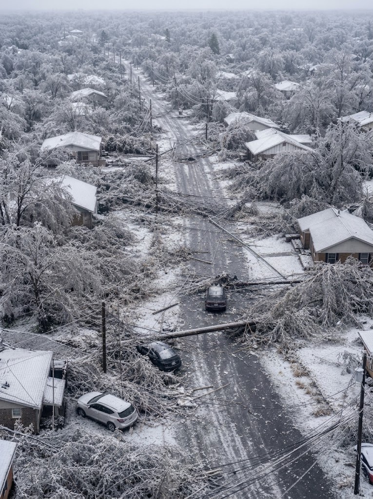
As accumulations approached half an inch in several jurisdictions, residential corridors turned treacherous. Neighborhoods across Davidson, Williamson, and Wilson counties echoed with a recurring series of sharp, gunshot-like reports: the sound of massive oak, pine, and hickory limbs snapping under structural stress.
A typical mature tree can carry thousands of pounds of added weight once coated in even a quarter-inch of ice. Unbalanced loads split major boughs directly down tree trunks, crushing fences, flattening parked vehicles in driveways, and tearing down utility service drops connected to homes.
In historic neighborhoods with dense tree canopies, such as East Nashville and Belle Meade, fallen limbs blocked entire two-lane streets. City public works departments and contract tree crews worked through freezing conditions with chainsaws, attempting to clear paths for emergency responders, fire trucks, and ambulances.
“We heard a loud crack, then an almighty crash right on the back patio,” said Mark Jennings, a homeowner in Brentwood. “A 40-foot limb from an old maple tree snapped clean off and took down our gutters. The street outside looks completely abandoned—nobody can get out of their driveways without sliding into a ditch.”
Utility Crews Battle Mounting Power Failures
The combination of iced-over distribution cables and falling tree canopies dealt a heavy blow to the regional energy grid. Tens of thousands of homes and businesses lost electrical service as high-voltage lines sagged and grounded out. In several locations, the accumulation was severe enough to snap wooden utility poles in half.
Linemen from local energy cooperatives and municipal distributors mobilized alongside mutual-aid crews called in from unaffected neighboring states. Restoration work, however, remains slow and hazardous:
-
Slick Roads: Heavy bucket trucks struggled to climb steep residential inclines and rural secondary routes to access damaged equipment.
-
Secondary Falls: Lineworkers had to work beneath compromised tree branches that continued to crack and drop unexpectedly.
-
Re-freezing: In many sectors, rain continued to fall while temperatures remained locked between 28°F and 31°F (-2°C to -0.5°C), immediately coating repaired conductors in fresh ice.
Emergency managers stressed the importance of home safety while the grid remained offline. Residents relying on portable gasoline generators were urged to operate them strictly outdoors, well away from doors and windows, to eliminate the danger of deadly carbon monoxide poisoning. Fire officials also discouraged using indoor ovens or gas stoves for space heating.
Mass Cancellations and Stalled Transit
The storm brought daily commerce and civic services across the region to a near-total halt. School districts across Middle and West Tennessee canceled classes preemptively or transitioned to remote instruction. State office buildings, university campuses, and municipal courthouses shuttered non-essential operations.
At Nashville International Airport (BNA), ground crews fought continuous ice formation on runways, taxiways, and fuselages. Airlines delayed hundreds of arrivals and departures as de-icing bays operated at peak capacity, leading to rolling cancellations that rippled through hub networks in Atlanta, Charlotte, and Chicago.
Interstate trucking also took a severe hit. TDOT cameras showed commercial rigs parked along highway shoulders, unable to negotiate rolling hills. Several logistics companies halted distribution center departures until pavement conditions could be scraped or salted.
Ongoing Safety Guidance and Outlook
With sub-freezing temperatures forecast to linger through the night, any moisture left on unplowed or untreated surfaces will remain frozen solid. Officials urge the public to follow critical safety precautions until a thorough thaw begins:
-
Avoid Non-Essential Travel: Keep roads clear so plows, salt trucks, emergency response squads, and repair crews can operate safely.
-
Watch the Canopy: Do not walk or park under large, ice-laden trees or sagging overhead wires. Treat all downed utility lines as active, live, and fatal.
-
Prevent Frozen Pipes: In homes without steady power or heating, open cabinet doors below sinks to allow indoor air circulation and let interior faucets run at a faint trickle.
-
Check on Vulnerable Neighbors: Ensure older adults and families with young children have access to sufficient blankets, shelf-stable food, warm clothing, and charged communication devices.
Meteorologists forecast that temperatures will slowly climb above the freezing threshold over the coming days, beginning the process of shedding the ice loads. Until then, Tennessee remains locked in a waiting game as cleanup crews and utility teams work to restore power and safely clear the state’s frozen thoroughfares.